


The Santa Cruz Trek is the most popular trek in the Cordillera Blanca. It lies northeast of Huaraz in the northern part of the range and is regularly traversed by trekkers, climbers, mountain bikers, and mountain runners from all over the world.
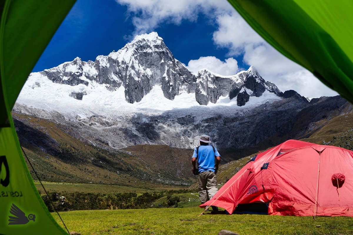
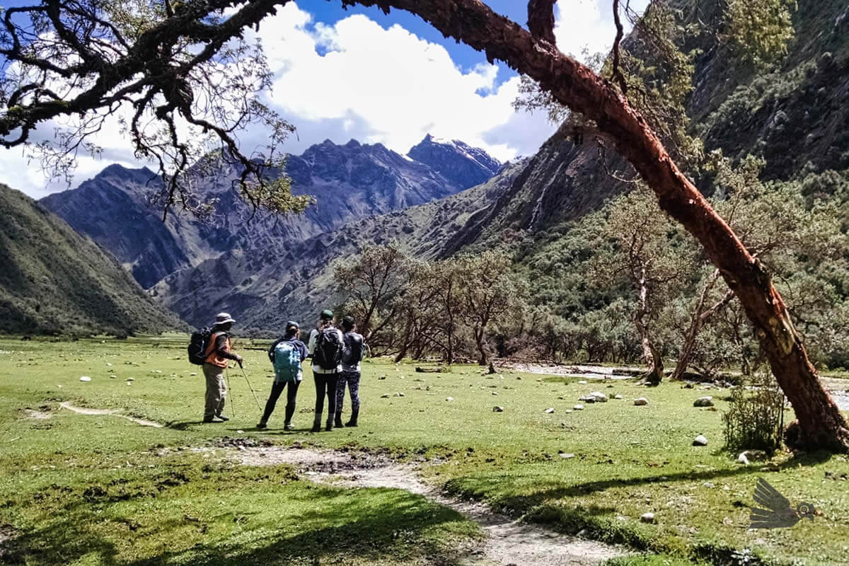
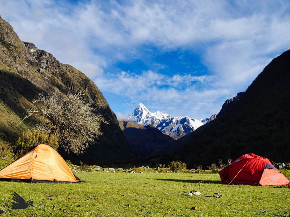
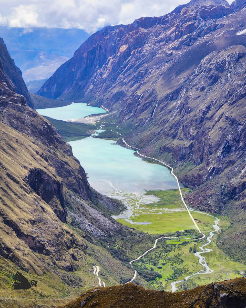
The route follows the spectacular Santa Cruz and Huaripampa Valleys as it passes through native quenual and quiswar forests and alpine lakes with excellent campsites all above 3700 meters. Some of the glaciated peaks, legendary to mountain climbers, that ring the valleys are Quitaraju 6036 m, Artesonraju 6025 m, Taulliraju 5830 m, and stunning Alpamayo 5947 m. Along the route you are also likely to see vizcachas, foxes, and many species of high-altitude birds.
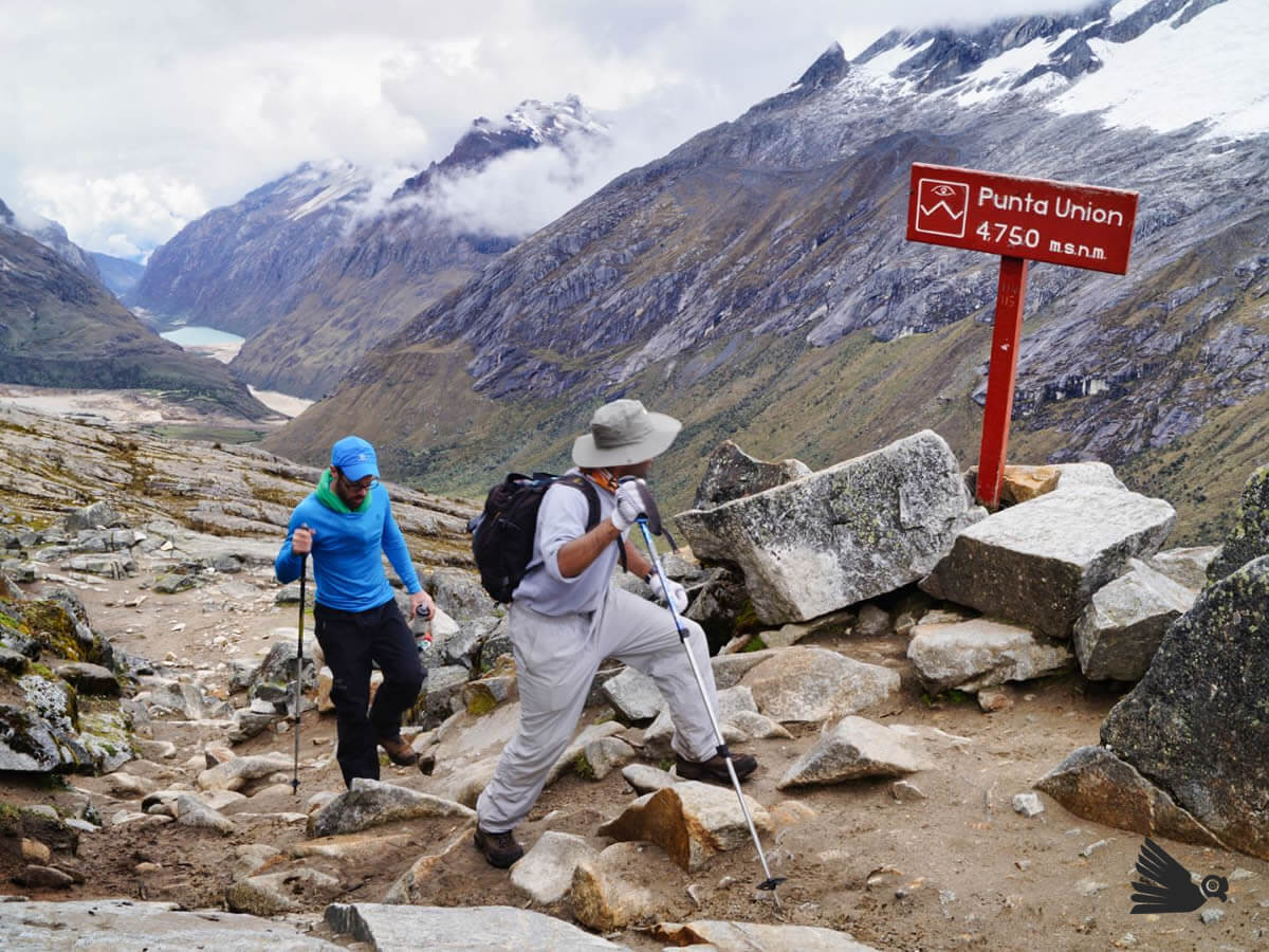
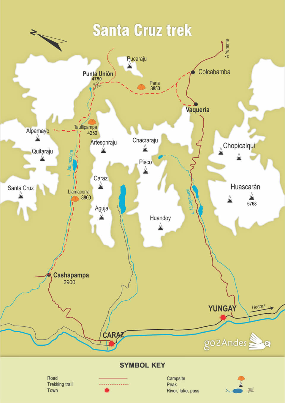
The Santa Cruz is normally done as a four-day trek, which totals approximately 45 kilometers with the highest point being at the continental divide, Punta Unión Pass (4750 meters above sea level). A typical day would include about 6 hours hiking.
Best time of the year to make the Santa Cruz trek
The Cordillera Blanca really just has two well-defined seasons: a rainy season from October to April, and a dry season from May to September. As you can imagine, the dry season is preferable for trekking even though July and August in particular can be a bit cold. The weather in the dry season isn’t always perfect; there are occasional rain showers or you could conceivably even see a bit of snow at high altitudes. For this reason it is always better to go prepared for all high-mountain conditions.
El clima en la Cordillera Blanca está bien marcadas por dos estaciones, temporada de lluvia (octubre – abril), y temporada seca (mayo – septiembre). La estación más recomendada es por supuesto la temporada seca, siendo los meses más fríos julio y agosto. Durante la temporada seca no podemos prometer que siempre será seca, ya que de vez en cuando llueve inesperadamente. Por ello recomendamos siempre estar preparados para cualquier adversidad del clima.
The average temperature during the day is 20 ° C, and at night it drops below 0 ° C.
Difficulty
Due to the number of days spent trekking, the long distances to any evacuation point, and the large elevation gain to the pass, the Santa Cruz Trek is considered moderate to difficult.
Acclimatization
The first key to a successful and enjoyable high-altitude trek is good acclimatization. It is strongly recommended that, before embarking, you spend a few extra days at an appropriate altitude to allow your body to adapt to the lower air pressure by creating more red blood cells that will ensure sufficient oxygen distribution to all of your organs.
People who are inadequately acclimatized commonly experience symptoms of Acute Mountain Sickness like headaches, exhaustion, loss of appetite, and even nausea. While these symptoms rarely lead to anything more serious, it is always wise to take acclimatization seriously. Being needlessly sick in the mountains is no fun at all. The most common approach for a trek like the Santa Cruz is to spend at least two or three days above 3000 meters doing day hikes, eating well, drinking plenty of water, and getting adequate rest.
Here is a list of short hikes you can do while acclimatizing in Huaraz: Ten Day-Hikes Easily Accessible from Huaraz.
If this is your first high-altitude trek, don’t do it solo. Find a group or go with a trip organized by a reputable trekking agency.
Starting point
The Santa Cruz Trek can be done in either direction: east to west or west to east. The trailhead on the east side starts in the village of Vaqueria at 3700 meters and on the west side it’s the village of Cashapampa at 2900 meters.
Although beginning the trek in Cashapampa requires that we gain a bit more total altitude, the gradual ascent helps with further acclimatization and has us crossing the pass on the third rather than the second day of the trek.
Sample itinerary of the Santa Cruz trek
Día 1: Huaraz 3100 m – Cashapampa 2900 m – Llamacorral 3760 m
Our adventure begins. We’ll get an early start for the drive in a private vehicle to Cashapampa where the donkey drivers will be waiting to load all our equipment onto their animals. As the donkeys are being loaded, we’ll begin walking up the canyon section of the Santa Cruz Valley. We’ll arrive at our first campsite, Llamaccorral, in the afternoon. This is generally the warmest day of the trek. Hiking time is four or five hours.
Día 2: Llamaccorral 3650 m – Taullipampa 4200 m
After a night camped under the stars, we’ll enjoy a delicious breakfast prepared by our expert mountain chefs. We’ll then spend the day gradually gaining altitude as we continue up the Santa Cruz Valley with the great summits of Quitaraju, Caraz, Rinrijrca, Artesonraju, and the legendary Taulliraju appearing one by one as we go along. Our campsite is in Taullipampa, which has an excellent view of the surrounding mountains. Hiking time is four or five hours.
We also have the option this day to make a side trip to visit Alpamayo Base Camp and Lake Arhuaycocha. Doing it this way extends the hiking time to seven or eight hours.
Día 3: Taullipampa 4200 m – Punta Unión 4750 m – Huaripampa 3700 m
Today is the highpoint of our trek in both senses of the word. Will you make it to the pass? Of course you will if you’ve already made it this far! With a sense of calm purpose we’ll begin the slow ascent to the famous Punta Unión Pass (4750 meters above sea level) where we will enjoy a panoramic 360-degree-view of the entire region. From this point we can see all the big glaciated peaks, the lakes we passed on the ascent, and the both the Santa Cruz and the Huaripampa Valleys. Eventually we’ll begin to descend into the Huaripampa Valley to our last campsite in Cachipampa. The hiking time this day is usually between seven and ten hours.
Día 4: Huaripampa 3700 m – Vaqueria 3700 m – Huaraz
After yesterday’s big day, today we’ll take things a little easier. We begin by continuing our descent down the Huaripampa Valley past the Huascaran National Park Ranger Station and then through the villages of Huaripampa and Coullur where we can see examples of traditional Andean rural life. The day’s walk finishes with a short uphill section, just enough to break a sweat, to finish in Vaqueria, which is a made up of a few houses along the road. Here our vehicle will be waiting to transport us back to Huaraz.
The return trip has one more surprise in store for us. We cross, this time in the comfort of our vehicle, one last big pass, Portachuelo (4770 m), where we’ll make a stop at a viewpoint to enjoy a breathtaking view of the Cordillera Blanca. From here we have up-close views of the northern and southern summits of Huascaran (the highest mountain in Peru 6768 m), the four summits of Huandoy, Pisco, and Chacraraju with the beautiful Llanganuco Valley at our feet. From here it is still a few hours drive to Huaraz where our adventure ends. Today’s hiking time is two or three hours. Driving time about five hours.
Camping and Restrooms on the Trek
During the trek we will sleep in tents. The Santa Cruz has designated campsites, but unfortunately none of these sites has proper restrooms, so the trekking agencies supply a toilet tent placed above a small hole dug in the ground.
If you would like to sleep in a bed when you are in the villages of Cashapampa or Vaqueria, there are very basic hotel rooms available.
Entrance Fees for Huascaran National Park
The Santa Cruz Trek lies entirely within the borders of a region protected by the government of Peru: Huascaran National Park. For this reason it is required that you pay an entrance fee of 150 nuevos soles. This ticket is valid to go in and out of the park for 30 days. If you are planning to do other treks within the park, don’t lose your ticket or they will make you buy another one.
Recommendations for a Successful Trek
The trekking agencies will generally manage all of the logistics for your trek. If you are traveling in a group with people you do not know, remember that you are in remote country and it’s important to work as a team and support anyone who may find the hiking a bit more challenging than you do. If you have any medical issues such as food allergies or anything else of any concern, let the guide know. To avoid getting lost while hiking make an effort to stay in sight of the guide and to stop at any fork in the trail until the guide catches up.
Make sure you always have a copy of your passport, a small first aid kit (even though the guide will have a more extensive one), a water bottle, a headlamp with extra batteries, a warm jacket, a rain jacket, and a little money with you as you hike.
Packing List for the Santa Cruz Trek
Temperatures on the Santa Cruz Trek generally range from 20°C during the day to 0 or a bit below freezing at night. The coldest months are July and August. Also remember that it is easy to get sunburnt at high altitudes. With this in mind, here is a basic packing list:
Upper half of body:
- A rain jacket in good condition or rain poncho
- A warm down or synthetic filled jacket
- 1-2 t-shirts
- A warm long sleeved synthetic shirt
- Neck gaiter
- A wide brimmed hat for the sun
- Knit hat for the cold
- Sunglasses
- Gloves
Lower half of body:
- 2 pairs of synthetic hiking pants
- 1 pair of pants to sleep in
- Hiking boots or shoes (make sure they are broken in)
- 1 pair of camp shoes
- Thick socks for sleeping
- 2 pairs of hiking socks appropriate for your footwear
- Underwear
Otros
- A daypack with sufficient space for your jacket, water bottle, camera, first aid kit etc.
- Sunscreen
- Lipbalm with sun protection
- A lightweight book or ebook
- Playing cards or some packable game.
Santa Cruz trek map
If you want to live an experience in the Andes of Peru, CONTACT US and we will be happy to help you.